The Inca: South American Empire
Part 1: Origins and Supremacy The Inca Empire stretched thousands of miles along the western coast of South America. At its height, this empire was the largest in the world. It enjoyed supremacy over its neighbors for a few centuries in the early Middle Ages but fell victim to conquest by Spanish forces. 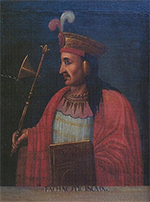
The Inca were not the first civilization in the Andes or in South America. The Tiwanaku and Wari lived in what became Inca lands for centuries in the first millennium A.D. A tribe led by Manco Cápac founded a small city-state called the Kingdom of Cuzco near the start of the 13th Century. This city would later serve as the capital of the Inca Empire. The Inca civilization was very much an empire, ruled by one man, who ruled supreme. The Inca rulers had more than one name. The title equivalent was Cápac, which meant something similar to "the only one," and was paired with Inca, to make "the only Inca." Thus, the first really well-known ruler was Cápac Inca Pachacuti (right), who ascended the throne in 1438. With the ascent of Pachacuti to the leadership of the Inca people came a thirst for conquering nearby tribes. The conquering began, as did the empire. Eventually conquered were the Chanca, Chimor, Colla, Lupaka, and Wanka civilizations. All of the conquered peoples retained their native languages, but the Empire also had its own official language, Quecha. All of these languages were spoken, not written. Pachacuti was also the leader who organized the construction of Machu Picchu, the fabled mountaintop fortress "rediscovered" in 1911. That leader's son Tupac took over for his father and greatly expanded the reach and influence of the Inca Empire. 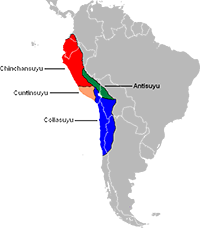
To refer to their realm, the Inca used the word Tahuantinsuyu; a rough English equivalent is "Land of the Four Quarters" (or, some sources say, "Realm of the Four Parts"). Cuzco was the center. The western quarter was Cuntisuyu; the eastern quarter was Antisuyu; to the north was Chinchaysuyu; and the name for the south quarter was Collasuyu. At its height, the Inca realm spread some 3,400 miles north to south, through what is now Argentina, Bolivia, Chile, Colombia, Ecuador, and Peru. From the seat of government at Cuzco, the Cápac Inca ruled about 10 million people. At its height, the capital's population exceeded 150,000. To govern and maintain this vast realm, Inca rulers had built two major roads. One ran north to south along the Pacific coast and slightly inland. The other road also ran north to south, nearer to the eastern edge of the Empire, and connected Cuzco itself with Next page > Zenith and Downfall > Page 1, 2
|
|


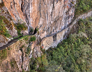 interior lands. Various east-west spurs connected the two main routes. The total was more than 25,000 miles of roads, over terrain hospitable and challenging, built to withstand both extreme and mundane weather, thereby providing speedy transport of people and animals and goods. One prime function of these roads was the transmission of messages, from Cuzco outward or from one part of the Empire to another. Messages traveled by relay, with runners staged along the roads carrying messages to the next runner in what could be a very long relay; thus, a message could travel up to 150 miles in a day.
Social Studies for Kids
copyright 2002–2026
David White