David Thompson: Canadian Explorer Extraordinaire
David Thompson was a fur trader who was the first European to travel the length of the Columbia River and who mapped more than 2 million square miles of North America. He was born on April 30, 1770, in Westminster, in England. His father, also named David, died when the boy was 2. Young David, tasked with attending the Grey Coat Hospital for the poor, applied himself to his schooling, learning mathematics and the basics of navigation. When he was 14, he earned an apprenticeship with the Hudson's Bay Company (HBC), a major player in the North American fur trade, and sailed across the Atlantic, arriving in Churchill, in what is now Manitoba, in 1784. 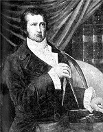
He spent the first two years of his apprenticeship doing paperwork, creating a copy of the personal papers of Samuel Hearne, the Fort Churchill governor. Thompson got a promotion of sorts in the form of a transfer to York Factory, out of which he served as a clerk in various capacities. He suffered a life-threatening injury in 1788, sustaining a serious leg fracture. He narrowly avoided death, and it took him two years to recover fully; he walked with a limp for the rest of his life. He spent the time studying with Hudson's Bay Company surveyor Philip Turnor, learning astronomy and surveying. He spent so much staring at the Sun and at the night sky that he lost the sight in one eye. Thompson's apprenticeship ended in 1790. HBC had a custom of giving its apprentices a gift of nice clothes at the end of their service; for his, Thompson requested a set of surveying tools. The HBC gave him both. As did many apprentices, Thompson then went to work for the HBC, in the fur trade. 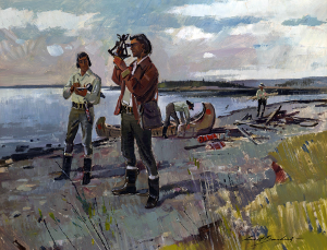
He spent less time as an employee than as an apprentice, leaving the HBC in 1797 and going to work for a rival company, the North West Company. He stayed with that company for 15 years. During that time, he ranged far and wide across the North American continent, surveying and mapping much of Western Canada, what is now Alberta, British Columbia, Manitoba, the Northwest Territories, and Saskatchewan. Estimates are that he traveled more than 50,000 miles in all. In 1810, Thompson was heading back toward Montreal when he got word that his employer wanted to find a route to the mouth of the Columbia River. The American Fur Company's John Jacob Astor had announced plans to send a ship from the East Coast to the West coast, around the tip of South America, in order to establish a fur trading post. This became the Astoria settlement. 
Thompson then became the first European to travel from the Columbia's origin to its mouth, arriving at Fort Astoria on July 14, 1811, two months after Astor's ship, the Tonquin had staggered into port. He stayed at the fort for a time, then headed home. He retired from the North West Company in 1812 and went to work for himself, setting up a private surveying practice. Among his targets in later years were the border between Canada and the United States in the east. During this time, he also completed a map of the area that he surveyed that was so accurate that it was used for more than a century afterward. (It now rests in Canada's National Archives.) The map contained not only fine details of the landforms and waterways but also observations of the cultures of the people that he encountered. 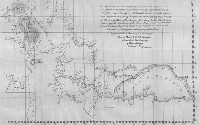 He retired for good not once but twice, taking up surveying again later in life because of more than one failed business venture. In desperation, he sold his maps to an English publisher, who paid him a pittance and then didn't publish them but used them to correct their own. His last project was an account of his experiences. Not just a recitation of facts and figures, it was a lively account of the adventures that he had along the way. He had to stop after a time because he lost sight in his left eye, in 1851. (He had lost the sight in his right eye a couple of decades before.) David Thompson died in 1857 and was buried in Montreal, poor and obscure and forgotten. He had married Charlotte Small in 1799. They eventually had 13 children together. Geographers and historians have rediscovered Thompson's work in recent years. He has appeared on a Canadian postage stamp, and statues depicting him dot the landscape in a few locations, in both Canada and the U.S. Named after him are a river and an observatory. |
|


Social Studies for Kids
copyright 2002–2026
David White