|
New Antarctica Map Is Highest Resolution Yet
September 8, 2018
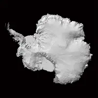
A group of scientists from two American universities has released what is said to be the most accurate, complete map of Antarctica yet made. The Reference Elevation Model of Antarctica (REMA), created by a joint project between the Ohio State University and the University of Minnesota, shows the height of all mountains and quantifies 98 percent of the ice and other landmasses on the frozen southern continent. The scientists used hundreds of thousands of models pulled from high-tech satellite images to create their new high-resolution topographic map. Plans include similar efforts in the future, in particular to track the dramatic increase in ice melt noticed in the past couple of decades. A 2018 study found that since 1992, Antarctica has lost more than 3 trillion tons of ice to melt, because of global warming. Many versions of the map, including an online web mapping application, are available at a University of Minnesota website. |
Social Studies for Kids |


Social Studies for Kids
copyright 2002–2019
David White