The London Underground Tube Map
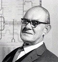
The London Underground, the world's first underground railway, dated to 1863. The first network map appeared only in 1908. The really famous map, however, appeared in the 1930s. Passengers had maps earlier than this, but the problem was that the Underground wasn't just one railway operating but several, and each company had its own map. Travelers sometimes had to change railway lines in order to get to Network maps were first produced late in the 19th Century and first given away to passengers in 1908. The Tube Map now recognized by hundreds of millions of passengers each year first saw the light of day in 1933, the creation of an engineer and entrepreneur named Harry Beck (right). Beck was a draftsman who had joined the Signal's Engineer's Office in 1925. He said that he got the idea for the design from viewing a drawing of the electrical circuit of the network. Beck removed all of his assumptions about what a map should look like and what it should show. He started out by asking the fundamental question of what people wanted, and what people wanted was to see all of the stops on one map. 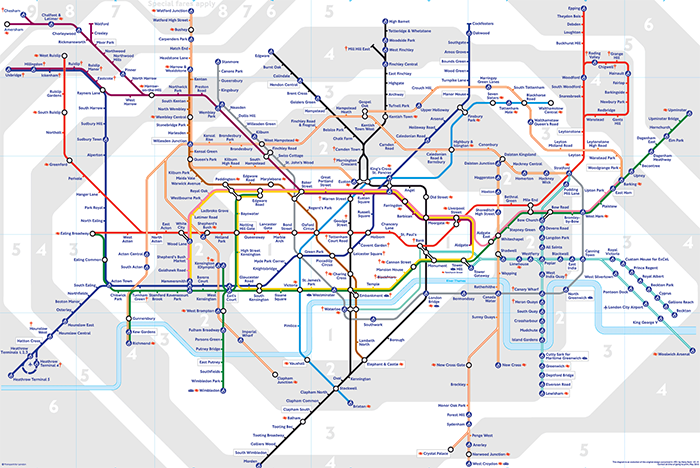
His first version came along in 1931, and the powers that be weren't all that keen on it. One objection was this: A person couldn't look at the map and tell how far it was from one station to the next. Beck's answer to that one: Why do you need to know how far it is? Just get on the train and get to the next station. Of paramount importance were where to get on and where to get off. The main thing was, he wanted to show all of the stations on one map that a passenger could take along, without having to carry loads of paper around. If Beck had done that showing any kind of geographical scale, the map would have been massive, and cumbersome. The idea eventually caught on. They printed 700,000 copies in 1933 and had to reprint within a month. The printed map was a runaway hit with passengers and continues to be popular. Beck updated his map time and again, as the Underground added more lines and stations. His last version came in 1965, when he left the bureau. Other people took over and did the updating, keeping to Beck's original design as much as possible. He got paid next to nothing for his map because he was a government employee and the government owned his creative output. But his name is still on every Tube map printed. Into the 21st Century, the Tube system in total covers 249 miles, linking 270 stations and 11 railway lines. Station distances run from 300 meters (984 feet) apart to 6.3 kilometers (4 miles) apart. The Tube Map still fits in a passenger's pocket.
People can also get really big versions of this, and people have taken to putting them on their walls at home like a poster. The Tube Map has become an icon. In recent decades, the Tube people have had fun with changing the names of the Tube stations according to a certain theme. |
|


 various places in London. Eventually, somebody came up with the idea to put everything on one map, and away they went.
Social Studies for Kids
copyright 2002–2026
David White