|
Why Is It That the U.S. Has Two Centers? The center of the United States is in two places because of history. The first time such a point was calculated was in 1941, when the U.S. had 48 states, all contiguous. At that time (in fact, it was back in 1918, as the result of the National Geodetic Survey), the United States Part of the reason for the drop in tourist traffic to the site near Lebanon, Kan., might be the fact that since 1959, when Alaska and Hawaii became states, a new candidate for geographic center of the country emerged, in South Dakota.cAccording to the National Oceanic and Atmospheric Association (NOAA), the town of Belle Fourche, S.D., can now lay claim Actually, many geographers would say that it's very difficult to find the exact center of something that is, in effect, a flat approximation of a spherical object, which a map of the United States really is, since Earth is not flat. The way that geographers make their calculation is by using what they the "center of gravity" method. In essence, you take a big piece of cardboard that is cut to match the entire country; then, take that big piece of cardboard and balance it on a pointed object, such as the head of a pin. Wherever the cardboard balances without falling off to the side, that's the center. Even that, though, is a two-dimensional estimate of a three-dimensional entity. Still, that's the way the Government did it back in 1918. Have a suggestion for this feature? Email Dave. |
Social Studies for Kids |


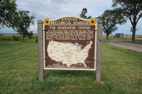 Geological Survey had located the center of the country at N39° 50' 00" W 98° 35' 00". This point was near the town of Lebanon, Kan. Residents of the town erected a monument, a motel, a coffee shop, and a souvenir shop and formed a Hub Club to help maintain it all. Annual visitors used to number in the thousands. The number of people who seek out this point has dwindled through the years. The monument is still there, at the end of the state's shortest highway, along with a chapel and a picnic table. The chapel has a guest book. Gone are the motel, the coffee shop, and the souvenir shop. Now, visitors can get souvenirs in Lebanon.
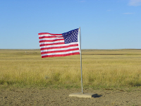 to the title of center of the country. A visitor center in the town is actually not on the center point; that, according to local authorities, is in the middle of a farmer's field. (It is now marked with an American flag.) The same is true of the former center spot, in Kansas. That one was in a farmer's field as well, about half a mile from the monument that "marked the spot." For the record, the South Dakota location is at N44° 58' 02.07622" N and W103° 46' 17.60283".