The River as Boundary
The river has always been and continues to be a boundary between areas where people live or gather.
Especially if the river was a wide one, crossing it was too much work. Except, of course, if you wanted to conquer your neighbors. Rivers have slowed down many a conqueror in times past. Even in the "modernized" 20th Century, rivers have played major parts in protecting countries from attack and slowing down attacks by determined neighbors.
Check out your map of the United States. Make sure it includes rivers. You'll find that the eastern boundary of Nebraska is also a river, the Missouri River. Rivers are boundaries for counties and cities, too. You can probably find some on the map of your state or area. And it's not just the United States. The Huang He River marks the eastern border of China's Shensi province. The Danube River helps form the border between Romania and Bulgaria. When it comes to boundaries, you don't get much more natural than a river. |
|


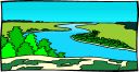 In
ancient times, rivers were natural boundaries. The people
living in one village would plant crops on one side of a
river, build living areas on that same side of the river,
and generally have no use for the land on the other side of
the river.
In
ancient times, rivers were natural boundaries. The people
living in one village would plant crops on one side of a
river, build living areas on that same side of the river,
and generally have no use for the land on the other side of
the river.
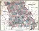 Rivers
make natural boundaries. It's a lot easier to just say that
the eastern boundary of the state of Missouri is the
Mississippi River in many places than it is to get a bunch
of surveyors and mark the boundary the hard way.
Rivers
make natural boundaries. It's a lot easier to just say that
the eastern boundary of the state of Missouri is the
Mississippi River in many places than it is to get a bunch
of surveyors and mark the boundary the hard way.

Social Studies for Kids
copyright 2002–2026
David White