Are You Map Savvy?
Part 2: Why Map Reading Is Important 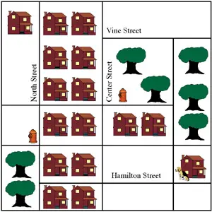 For example, let's say you live on North Street and your friend lives on Hamilton Street. Look at the map above. Your house is on North Street. Your friend's house is the one with the dog out front. How would you tell your friend to get to your house? You'd want your friend to take the most direct route possible. So, you'd say to your friend, "Take Hamilton Street to North Street. Turn right on North Street, and go to the end of the street. My house is on the left." You wouldn't want to tell your friend to turn on Center Street because no other street connects Center Street and North Street. (Encourage your friend to walk on the sidewalk, of course.) 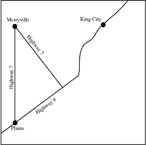 In the same way, you would want to tell your friend who lives in Plains to take Highway 9 to get to your house in King City. If your friend takes Highway 7, he or she will have to travel to Merryville and then come back to Highway 9. The trip will be many miles longer than it has to be. It's not vital that you tell your friend the shortest way to get to your house, but your friend will like you better if he or she doesn't have to take the long way around to come see you. You and your friend will also have more time to spend together. If you know how to read a map like this, you can also give other people directions. Then, you can tell these people the shortest route, too. (And if they don't know to how to read a map, you can show them!) When you look at a map of a city you are traveling to, you see street names and also names of attractions. If you are traveling to Washington, D.C., you will see the names of many government buildings and museums. Knowing how to read this map will help you get to places you haven't been to before. (You could always ask someone, but you don't want to ask someone for help every single time, do you?)
The primary importance of maps is to help you understand the world around you. Street maps show your immediate surroundings. National maps show landforms and bodies of water. Country maps show neighbors and borders. World maps show all these things. Know how to read maps, and you'll see the world around you in a whole new light. First page > Kinds of Maps > Page 1, 2 |
|


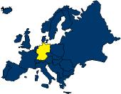 When
you look at a map of Europe, you can see which countries
border a certain country. For example, you can see that
Germany has many neighbors, including France, Italy, Poland,
and the Netherlands. If you travel to Germany, you know you
won't have far to go to visit these other four
countries.
When
you look at a map of Europe, you can see which countries
border a certain country. For example, you can see that
Germany has many neighbors, including France, Italy, Poland,
and the Netherlands. If you travel to Germany, you know you
won't have far to go to visit these other four
countries.

Social Studies for Kids
copyright 2002–2026
David White