Basic Geography: The Equator and the Prime Meridian
The earth is a globe, of course, and can be divided into lots of lines called latitude and longitude. Latitude lines run east and west and measure north and south; longitude lines run north and south and measure east and west. The lines measure distances in degrees. But where do you start? Where is 0 degrees? Well, that depends on whether you're looking for 0 degrees latitude or 0 degrees longitude. They are different things.
The prime meridian
is 0 degrees longitude. By using the equator and prime meridian, we can divide the world into four hemispheres, north, south, east, and west. For instance, the United States is in the Western Hemisphere (because it is west of the prime meridian) and also in the Northern Hemisphere (because it is north of the equator). The earliest maps have the equator marked on them, but it wasn't until the late 19th Century that the prime meridian was named. Until that time, as many as 14 different locations were being identified on various maps as 0 degrees longitude. The International Meridian Conference of 1884 changed all that, naming an imaginary line drawn through Greenwhich, England, as the prime meridian. These lines are drawn only on maps and globes, however. You won't find an "equator line" on the streets of Brazil. These lines are merely for the identification of where things are on a map or a globe. |
|


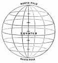 The
equator is 0 degree latitude. This imaginary line,
which runs through parts of South America, Africa, and Asia,
is officially the halfway point between the North Pole and
the South Pole.
The
equator is 0 degree latitude. This imaginary line,
which runs through parts of South America, Africa, and Asia,
is officially the halfway point between the North Pole and
the South Pole.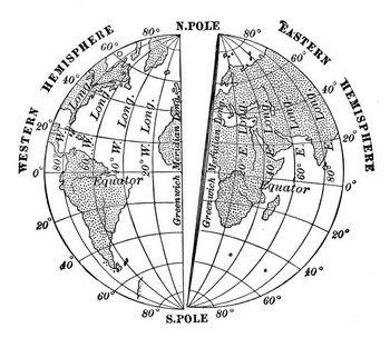 This imaginary line runs through the United Kingdom, France,
Spain, western Africa, and Antarctica.
This imaginary line runs through the United Kingdom, France,
Spain, western Africa, and Antarctica.
Social Studies for Kids
copyright 2002–2026
David White