Book Review: The National Geographic Student Atlas of the World
The operative word of this book's subtitle, A Comprehensive Reference for School and Home, is comprehensive. This is one of the most far-reaching reference books I've ever seen. And it's brand new for 2002. It has all the standard maps, charts, and graphs, of topography, population density, agriculture and economies, political boundaires, weather patterns, etc. It also has such nonstandard maps as Natural Hazards, showing the locations of such things as hurricanes, floods, volcano eruptions, and more. 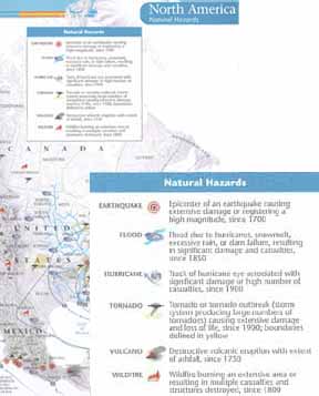 The book is colorful to the extreme: The colors are vivid and complementary and seem to blend together to present a colorful whole full of information that is very easy on the eyes. Also included are facts about every country in the world, including flags and up-to-the-minute population statistics. It can be argued that National Geographic does this kind of thing better than anyone else. Based on this book, I wouldn't disagree. Graphics courtesy of National Geographic
|
|


Social Studies for Kids
copyright 2002–2026
David White